Old Bynum Bridge
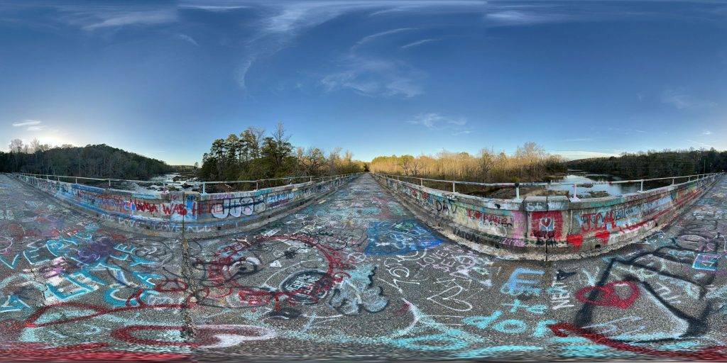
This bridge stands as a testament to the evolution of infrastructure and the enduring power of community spaces in preserving local heritage and fostering social connections. From its origins as a state-of-the-art transportation link to its current role as a beloved community hub, the Old Bynum Bridge is truly a unique and cherished part of Pittsboro’s history. Below is a 360-degree panoramic image showcasing the bridge. Take a moment to look around and enjoy the scene.
Image by: Benjamin Wolf
About the Abandoned Bridge
The Old Bynum Bridge in Pittsboro, North Carolina, is a rich tapestry of history, community, and transformation. This blog post delves into its past, present, and significance as a cherished local landmark.
The Historical Context and Construction of Old Bynum Bridge
Constructed between 1922 and 1923, the Old Bynum Bridge was a product of modern engineering and state-of-the-art design of its time. The bridge was built by the North Carolina Department of Transportation (NCDOT), which still maintains it today. Spanning the Haw River in the Piedmont region of North Carolina, it replaced an earlier covered wooden bridge, linking significant towns such as Chapel Hill to the north and Pittsboro and Sanford to the south.
This reinforced concrete tee beam bridge stretches 806.1 feet across the river, encompassing nineteen spans of approximately 43 feet each. Notably, at the time of its construction and for many years thereafter, it was the longest bridge of its kind in North Carolina.
Operational Period and Closure
The Old Bynum Bridge served as a vital north-south highway connector for several decades. However, due to safety concerns, it was closed to motor vehicle traffic in 1999. Cars now cross the Haw River on the newer US 15-501 bridges located about 1000 feet north of the Old Bynum Bridge.
The Bridge Today: A Hub of Community and Culture
Today, the Old Bynum Bridge has been repurposed into a pedestrian bridge and is part of the statewide designated bicycle route. It has become a gathering place for the local community, playing host to a variety of activities and events. Some of the popular uses of the bridge include:
- Community Events: The bridge is a venue for the 4th of July picnic, stargazing, birdwatching, yoga, walking group meetups, and leisurely strolls over the river. It connects the two halves of Bynum, facilitating a sense of community and togetherness.
- Educational and Recreational Activities: The Chapel Hill Astronomical and Observational Society and the Bynum Astronomy Club utilize the bridge for stargazing due to its clear view of the night sky. The National Audubon Society recognizes it as an excellent bird-watching spot.
- Cultural Significance: The bridge has hosted Bridgefest, an art show, and the popular Halloween event “Pumpkins on the Bridge”, sponsored by the community nonprofit Bynum Front Porch. This event features hundreds of Jack-O-Lanterns and attracts numerous visitors.
- Personal Celebrations: The bridge has also served as a picturesque venue for weddings, offering a unique and historical backdrop for special occasions.
Continued Role in Public Infrastructure
Despite no longer being a major roadway transit point, the Old Bynum Bridge continues to play a vital role in public infrastructure. It supports an important interconnection for water service between the Haw River water supplies of the Town of Pittsboro and the Jordan Lake Northern Chatham County supplies. In essence, while it has ceased to function as a bridge for vehicles, it still connects communities and people, both literally and metaphorically.
Historical Recognition
In recognition of its historical and cultural value, the Old Bynum Bridge was added to the National Register of Historic Places on April 23, 2020. This inclusion highlights the bridge’s significance as a historic place worthy of preservation and underscores its importance as a symbol of local heritage and community identity.
If you liked this blog post, you might like these as well, the Cross Florida Barge Canal project, the McIntosh Sugar Works in Georgia, or the Rhyolite School House in Nevada.

A 360-degree panoramic image captured in the center of the now abandoned Old Bynum Bridge in Pittsboro, North Carolina. Image by Benjamin Wolf
Do you have 360-degree panoramic images captured in an abandoned location? Send your images to Abandonedin360@gmail.com. If you choose to go out and do some urban exploring in your town, here are some safety tips before you head out on your Urbex adventure.
Unlock the secrets of exploration by diving into precise GPS data available exclusively for an array of hidden gems and hundreds of other captivating sites, all within our members’ section. By investing in a Gold Membership, you’re not just gaining access; you’re securing a key to a vast, global archive of abandoned, untouched, and mysterious locations waiting to be discovered. Embark on your adventure with confidence, knowing every corner of the world can be within your reach. Don’t just observe—explore, discover, and claim the extraordinary journey that lies ahead with our treasure trove of world secrets. Subscribe now and transform the way you see the world! If you want to start shooting 360-degree panoramic images, you might want to look onto one-click 360-degree action cameras.
Click on a state below and explore the top abandoned places for urban exploring in that state.


